
Eight Days of Search & Rescue: How Drone Harmony Supported Emergency Teams in Venezuela
Following severe flooding in Venezuela, 80 rescue personnel spent eight days searching a challenging river corridor for two missing people. Drone Harmony supported the operation by enabling structured aerial search missions across difficult and hazardous terrain.
When a River Becomes a Search & Rescue Challenge
On August 22, 2026, heavy rainfall caused a sudden rise in the Río Aragua near La Victoria, in Venezuela's José Félix Ribas municipality. The powerful current swept away a vehicle carrying two people. Although rescue teams later located the vehicle's chassis in the riverbed, both occupants remained missing.
What followed was an extensive Search & Rescue operation involving approximately 80 rescue personnel working over eight consecutive days.
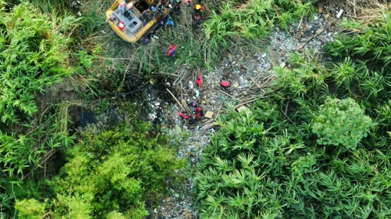
Organized into specialized rescue squads, the teams searched an 8–10 kilometre stretch of the Río Aragua, concentrating on two major search areas.
The environment presented significant challenges: unstable riverbanks, dense vegetation, accumulated debris, difficult access routes and a constantly changing landscape shaped by the floodwaters.
To support the operation, Protección Civil Aragua turned to drone technology and Drone Harmony's automated flight-planning capabilities.
Planning Aerial Searches Across 10 Kilometres of River
Searching a winding river corridor is far more complex than surveying an open field.
Potential search locations can be hidden beneath vegetation, behind accumulated debris or along steep and inaccessible riverbanks. Conducting a thorough search requires a systematic approach that minimizes gaps in aerial coverage.
Using Drone Harmony, the emergency response team planned structured flight paths following the Río Aragua. The missions incorporated different flight altitudes and camera angles to examine the terrain from multiple perspectives.

Flights were planned at approximately 54–80 metres above ground level, combining near-vertical imagery with oblique camera views.
This approach helped the team plan aerial inspections of:
Riverbanks and areas affected by erosion
Dense vegetation and partially obscured sections of the river
Accumulations of logs, branches and flood debris
Exposed riverbeds, mudflats and sediment deposits
Areas difficult or potentially dangerous to access on foot
By planning repeatable flight patterns, the team could approach the search area systematically rather than relying exclusively on manual drone navigation.
Combining Visual Search with Detailed Aerial Mapping
In addition to the longitudinal river search, Protección Civil Aragua planned a dedicated 27-hectare photogrammetric survey of flood-affected terrain.

The mission used a double-grid flight pattern with 75% forward and 65% lateral image overlap, designed to support the creation of high-resolution orthomosaics and Digital Surface Models. The two mission types served complementary purposes.
Visual reconnaissance allowed responders to examine specific sections of the river from different angles, while photogrammetric mapping provided a structured way to document larger areas and support subsequent spatial analysis. Together, these approaches helped organize the aerial component of a complex search operation.
Connecting Aerial Observations with Ground Rescue Teams
Drone technology is most valuable in emergency response when the information collected can be used by the people coordinating and conducting the operation.
During the Río Aragua search, the aerial workflow was designed to identify locations of interest and communicate georeferenced observations to rescue personnel on the ground.
Coordinates and potential anomalies could be shared with search squads and diving teams, helping them prioritize areas for closer inspection. This connection between aerial reconnaissance and ground operations is particularly important in hazardous environments.
Instead of relying solely on physical access to inspect every section of the river, emergency teams can use aerial information to support their assessment of where further investigation may be needed.
Eight Days of Determined Search Efforts
The operation continued for eight consecutive days, involving approximately 80 rescue personnel working in coordinated teams.
Despite the extensive efforts, the outcome was tragic.
The first missing person was recovered on the fourth day of the search. The second was recovered on the seventh day. Sadly, neither survived.
The operation nevertheless enabled both individuals to be returned to their families.
Behind the technical planning, aerial missions and coordinated rescue activities were people working tirelessly under difficult circumstances.
The dedication of the rescue personnel throughout those eight days deserves recognition, as does the importance of providing families with answers after such a devastating event.
While drones supported the aerial search effort, the available information does not establish whether drone observations directly contributed to either recovery.
From Earthquake Assessment to Search & Rescue
This was not the first emergency operation in which Protección Civil Aragua had used Drone Harmony.
Following the earthquakes of June 24, 2026, the organization had already applied automated drone flight planning to inspect affected buildings and map unstable mountainous terrain.

Those missions included structural documentation of buildings in Maracay and photogrammetric surveys of landslide-prone areas where ground access was difficult or unsafe.
Drone Harmony provided a Professional software license free of charge to support these humanitarian operations. Just weeks later, the same technology was being applied to a very different emergency.
Instead of planning missions to document structural damage or map landslides, the team was designing flight paths to support a coordinated search along a flooded river.
The two operations demonstrate how adaptable drone flight planning can be across different emergency scenarios.
Whether the objective is to assess damaged infrastructure, document unstable terrain or support a Search & Rescue mission, the underlying challenge remains similar:
How can emergency teams gather reliable aerial information efficiently while minimizing unnecessary exposure to dangerous environments?
Technology in Support of the People Who Respond
Drone Harmony is proud to support Protección Civil Aragua and the dedicated professionals who carry out this essential work.
By providing access to its software for humanitarian operations, Drone Harmony aims to make advanced flight-planning capabilities available to organizations working in challenging emergency environments.
The collaboration in Venezuela demonstrates the potential of combining automated drone missions with the expertise, judgement and commitment of trained rescue personnel.
Technology cannot prevent every tragedy, nor can it replace the people who put themselves at risk to help others. But it can provide additional tools to support their work, improve the organization of aerial operations and help teams make better-informed decisions in difficult conditions.
Our deepest condolences go to the families of the two victims. We also extend our sincere appreciation to the 80 rescue personnel and everyone involved in the operation.
Drone Harmony remains committed to supporting humanitarian organizations and emergency response teams around the world.
Are you part of an emergency response organization exploring how drones could support your operations? Contact us to learn more about our technology and humanitarian initiatives.


Comments