The Role of Technology in Monitoring Natural Disasters: A Case Study of the Blatten Landslide
- Aug 6, 2025
- 4 min read
Updated: Aug 27, 2025
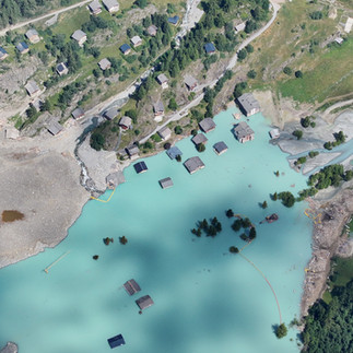
In the wake of the devastating rockslide in Blatten, Valais, Switzerland, technology has played a pivotal role in both disaster assessment and future risk management. Through innovative drone operations and automation, specialists have been able to gather crucial data to aid in risk analyses, create predictive models, and ensure public safety in an area previously considered too unstable and inaccessible for traditional surveying methods.

One of the standout features of this operation is the use of DJI Docks, managed with Drone Harmony software. These autonomous systems allowed drones to conduct surveys in some of the most challenging conditions, such as unstable rockslides and steep, alpine terrain. By integrating automation, the operation could proceed with minimal human presence, reducing exposure to dangerous environments while still gathering precise, real-time data. This collaboration between Remote Vision and Terradata is an impressive example of how technology can be leveraged to support disaster management and ensure safety.
Automated Drone Operations in Challenging Terrain
What sets this operation apart from traditional drone flights is the level of automation that has been integrated into the process.

The daily routine begins with a comprehensive situational awareness setup. The drones' operators, not physically present on-site, rely on real-time data feeds from various technical systems to monitor the weather, track other airspace users, and assess the status of the drones. Given the complexity of coordinating with other aerial services like Air-Zermatt and the Swiss Army, the operation uses specialized airspace monitoring systems like Skylens, which display all aircraft within range, ensuring safe and coordinated flights.
Thanks to the flexibility of the autonomous systems, flights can be executed quickly without requiring constant on-site presence, reducing the risk of human error and exposure to the hazardous environment. The DJI Dock’s ability to function autonomously, combined with real-time communication, ensures minimal disruption and faster data collection.


Precision in Data Collection and Georeferencing
Georeferenced data is crucial for the accurate modeling of the landscape, and here, technology again proves invaluable. Using RTK-GNSS correction, the drones' position is refined to within approximately 10 cm accuracy. This is complemented by ground control points deployed by Terradata, ensuring that the data remains precise and reliable throughout the survey. The combined use of Starlink and LTE routers allows for consistent data transmission even in remote areas where traditional connectivity might fail.

Photogrammetry software has also been optimized to handle challenging environmental factors such as fluctuating light conditions, snow cover, and shifting weather patterns. This is critical for ensuring that data remains consistent, even as these natural elements can drastically alter the visual landscape. By flying drones at various altitudes and angles, operators can mitigate issues like shadowing and inconsistent light, producing high-quality, usable images that form the basis of 3D models.
Creating Actionable 3D Models
The next step in the data collection process is the generation of 3D models. These models are not only visually striking but serve a critical role in terrain analysis. The point clouds generated by the drones are the foundation of these models, allowing for detailed surface renderings and measurements.
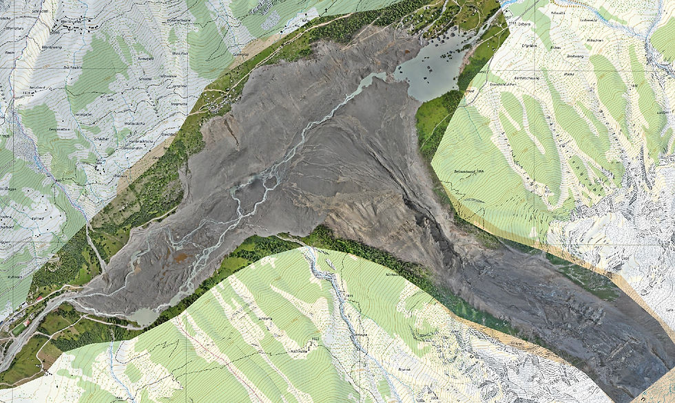
These models have proven to be instrumental for local authorities and response teams. By analyzing the terrain's changes in real-time, officials can track areas of rapid subsidence or new elevations, helping to predict potential future landslides and inform risk management strategies. The ability to visualize and analyze these changes is also helping to refine simulation calculations, offering valuable insights into the geohazards of the region.
Supporting Decision-Making with Timely Data
The speed at which data is collected and processed is one of the most significant advantages of the automated system. Since the deployment of the drone system in Blatten, detailed surveys have been carried out almost daily, allowing authorities to keep track of any new developments. As the situation stabilizes, the frequency of surveys has decreased to weekly intervals, with the ability to ramp up again if further shifts or new rockfalls occur.
Terradata’s Tedamos system plays a crucial role in visualizing these changes, providing local authorities with accurate, up-to-date models that aid in decision-making. This ongoing monitoring capability ensures that data is always available when needed and allows for quick responses to emerging threats.


The Power of Collaboration
The success of the Blatten operation is not just a testament to the technology itself but also the seamless collaboration between Remote Vision, Terradata, and local authorities. From data collection to interpretation, each partner plays a crucial role in ensuring that the results are quickly and efficiently used to make informed decisions on the ground.
The cooperative approach extends to ensuring that data reaches decision-makers in real time. With automated processes and no need for manual intervention, survey results can be delivered almost immediately after collection. This efficiency allows for rapid decision-making, which is critical in disaster zones.
Looking Ahead: The Future of Drone Technology in Crisis Management
The Blatten landslide has underscored the potential of autonomous drone systems in monitoring and managing natural disasters. The ability to map vast areas quickly, safely, and with a high degree of precision is invaluable, not just in the aftermath of an event, but in the ongoing monitoring of risk areas.
Moving forward, the expansion of drone technology into crisis zones and for preventive surveillance will likely become more widespread. The ability to generate 3D models of real-world terrain in real time is a powerful tool for future disaster response and for understanding environmental changes. With automated systems like DJI Docks, the integration of drones into emergency management is set to grow, offering more accurate, faster, and safer solutions for assessing and mitigating environmental risks.
“At Drone Harmony, we believe that the future of disaster response lies in the seamless integration of autonomous drone systems. As technology evolves, we are committed to empowering professionals with even more efficient, reliable, and scalable tools that will help monitor, analyze, and mitigate environmental risks in real-time, ensuring safer and more resilient communities.”
Martin Fuchsberger, CEO Drone Harmony
As technology continues to evolve, its role in disaster management and prevention will become even more critical, ensuring that communities can better prepare for, respond to, and recover from natural catastrophes.


Comments